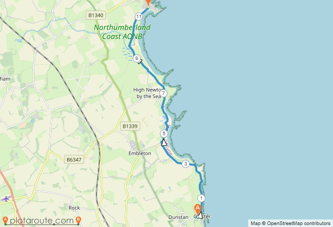
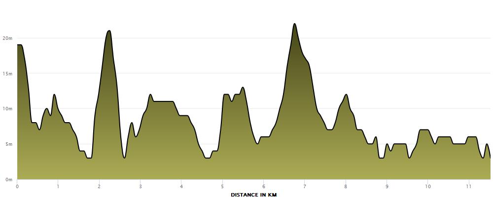
About 11.5km Point to Point
The Northumberland coastline is beautiful and it is probably no surprise to find several marked footpaths along its length. This includes the Northumberland Coastal Path that runs for 100km from Cresswell in the south to Berwick-upon-Tweed in the north. This run takes in a section that is about 11.5km long and is a great point to point run.
https://www.plotaroute.com/route/1995094?units=km
This route starts in the village of Craster. There is well signposted car parking on the entry to the village in an old quarry and this is where the saved route begins. I think there are regular buses as well (although never tried). You may choose to have a slight explore of Craster before you begin with its old smoke houses and small harbour. Likewise, if you choose to flip the route and come the other way, I can recommend the Jolly Fisherman Pub as a finish point.
Starting from the car park it is a short run down the hill to the harbour where you will bear left. A lot of the people parking is Craster will be heading to nearby Dunstanburgh Castle so you will be following the crowds. There are a couple of gates to negotiate but you will soon be back on your way.
This first stretch to the castle is used as grazing land for sheep and is a bit multi terrain. I have always run during summer months so the ground has been hard and I have been fine in road shoes but trails would probably be helpful the rest of the year. Keep and eye out for loose rocks and sheep poo but the path here is very wide so you can make your own way around any walkers etc.
Dunstanburgh Castle itself is an English Hermitage site so you have to pay to go in. When running this route I have on several occasions walked this far with my family, had a picnic in the castle and then started the run from here while they head back to Craster and the car. However, if you are not wanting to stop this isn’t an issue as the path skirts around to the left of the castle just after you have hit the 2km mark.
Once past the castle, you will hit a slight fork in the path. Go right and the path continues along the sand dunes, go left and it is a flatter, grassing path alongside the golf club. Personally I always go left as there is plenty of sand dune work later on. They rejoin at around 3.5km anyway and from this point you have to stay inland of the golf course for a while. At this point is also one of the other car parks for people accessing the castle, so once past here, the paths should be a little quieter.
Continue following the path and then at around 4.5km you will reach the golf club house. At this stage the path crosses the gold course. It is well signposted but just be aware of golf balls! At this stage you will also start to see a change in the terrain. You will follow the path up and over the sandy dunes. The path is still well defined but be careful as there are multiple trip hazards.
As you approach 5km you may worry that you have made a mistake as the path starts to wind in and out of some holiday houses. It feel strange as you pass by someone’s back window but that is the path so just stick on it and you will soon reach a slightly firmer path where you will swing right to keep heading North.
This path will take you through a small copse of trees and after you hit the 6km marker, you will then join a proper road/driveway that takes you in to Low Newton-by-the-Sea. The road takes you round the back of the pub (worth a separate visit) before heading left up the hill and away from the beach.
You only want to head about 60m up the road before you will see a kissing gate on the field (houses behind you) and you want to go through this. At this point the path does fork again. For this run you want to take the left fork heading up the hill. Going right takes you round the headland and adds about a km to the distance (I did this once in error at the end of a long run coming back this route that I wasn’t grateful for!)
This path is grass and pretty easy to follow. It goes a bit rough as you follow round past a rock escarpment, around the time your watch will be buzzing 7km and as you approach Newton Steads car park at around 8km it will switch to a sandier base.
You are now on the final stretch with the next couple of km running on the sandy land behind the dunes. Its fine under foot although can be a little energy sapping if you have started to tire. The path will bring you to the Long Nanny bridge and at this point you could choose to run the rest of the route along the beach. However, I prefer to follow the path which will bring you to the Beadnell Bay Caravan Park. The final km will then take you through the caravan park before you finish at the Beadnell Bay car park. Because of where we usually stay, I then continue along the main road through Beadnell but this only works if you are not being picked up!
If you are looking for a post run drink then the Craster Arms is a great shout (and would add about 1km to your route)
If you have done this route yourself, or have any questions, then please do leave a comment below!
Find all my Runs on the Road here!

